


la Bastide_le lachens19

bernir
User
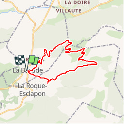

Length
15.2 km

Max alt
1678 m

Uphill gradient
713 m
Km-Effort
25 km

Min alt
1000 m

Downhill gradient
713 m
Boucle
Yes
Creation date :
2019-11-07 08:36:55.577
Updated on :
2019-11-08 16:49:41.717
6h35
Difficulty : Medium

FREE GPS app for hiking
 SityTrail
IGN / Geographical institutes
SityTrail Plus
The world is yours!
About
Trail Walking of 15.2 km to be discovered at Provence-Alpes-Côte d'Azur, Var, La Bastide. This trail is proposed by bernir.
Positioning
Country:
France
Region :
Provence-Alpes-Côte d'Azur
Department/Province :
Var
Municipality :
La Bastide
Location:
Unknown
Start:(Dec)
Start:(UTM)
308779 ; 4845064 (32T) N.
Comments